Speaking to Lusa news agency, the meteorologist from the Portuguese Institute of Sea and Atmosphere (IPMA) said that for today it is expected an increase in the maximum temperature of around 4/7/8/9 degrees in the western coastal regions.
"We will also have today a decrease in wind intensity compared to previous days. Gradually temperatures tend to rise also on the 15th and 16th [Thursday and Friday] and will remain high at least until the 17th [Saturday]. On Sunday, a drop in maximum temperatures is forecast", she said.
According to Maria João Frada, maximum temperatures will reach Saturday with values varying between 30 and 35 degrees, but in some places on the coast, Tagus Valley, Douro Valley and interior of the Alentejo will be higher and should range between 37 and 40 degrees.
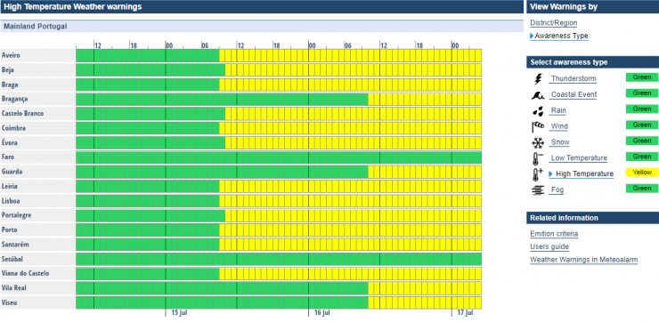
"So we are issuing warm weather warnings initially for the coastal districts because the rise today is on the coast, but with the gradual rise over the next few days, these warnings extend to the inland regions. The only ones that in principle will not have a warning will be the districts of Faro and Setúbal," said Maria João Frada.
The IPMA issued a yellow hot weather warning for the districts of Bragança, Viseu, Evora, Porto, Guarda, Vila Real, Santarém, Viana do Castelo, Lisbon, Leiria, Beja, Castelo Branco, Aveiro, Coimbra, Portalegre and Braga.
This yellow warning will be in force between 10am on Thursday and 5am on Saturday.
"In the coming days we will have little cloudy or clear skies with warm weather and above average temperatures and in some places contributing to heat wave because they are five degrees above what are the average values for the time of year in some IPMA stations. It does not mean that there will be a heat wave, but the temperatures are high. We are also in summer and all this is normal", she stressed.
As of Sunday, according to Maria João Frada, temperatures will drop 4 to 7 degrees Celsius.
"Already from today we will have the installation of an easterly current, a wind from the interior of the Iberian Peninsula that carries masses of warm air. This wind comes to the coast and hence the rise is today on the west coast and then extends, but then on Sunday the entry of sea air is expected, a wind with a maritime component that is cooler and will bring down the maximum temperatures," she explained.